LEVELLING AND ITS TECHNICAL TERMS

What is Levelling?
Levelling is defined as the process of determining the relative heights or elevations of points or objects on the earth’s surface. The elevation of a point is defined as its vertical distance measured above or below a reference level which is called datum. The most widely used datum surface is the Mean Sea Level, M.S.L.
Leveling is done for all important engineering works and construction projects. Some of the purposes for which leveling is done are listed below:- To find the elevations of points on the earth’s surface for topographic maps.
- For design of highways,railways,canals,sewers etc.
- For locating grade lines
- For laying out of construction projects
- For locating excavating levels
- To determine the drainage characteristics of an area
- Determination of volumes of earthwork for roads,railways etc.
TECHNICAL TERMS USED IN LEVELLING
Reduced level (RL): The reduced level of a place is its elevation or vertical distance above or below the datum or any fixed point.
Line of sight: It is the imaginary line joining the intersection of the crosshairs of the diaphragm to the optical centre of the object glass and its continuation.
Backsight (BS): A backsight is the first staff reading taken after setting up the instrument at any position. This will always be reading on a point of known elevation. Backsight enables the surveyor to obtain the height of the instrument.
Foresight (FS): A foresight is the last staff reading taken before shifting the instrument. This will always be reading on a point whose elevation is to be determined. This reading indicates the shifting of the instrument. It is also generally known as minus sight as the fore sight-reading is always subtracted from the height of the instrument (except when the staff is held inverted) to obtain the elevation.
Intermediate sight (IS): An intermediate sight is any staff reading, taken on a point of unknown elevation, after the back sight and before the foresight. This is necessary when more than two staff readings are to be taken from the same position of the instrument. It may be noted that for one set of a level there will be only a backsight and foresight but there can be any number of intermediate sights.
Changepoint (CP): This is an intermediate staff position and it is used for the purpose of shifting of the instrument. Both backsight and foresight are taken from this intermediate staff position. Great care is necessary for taking readings at the change point since an error in reading affects every succeeding point of observation (elevation). Any firm point, which can be easily found, may serve as a change point.
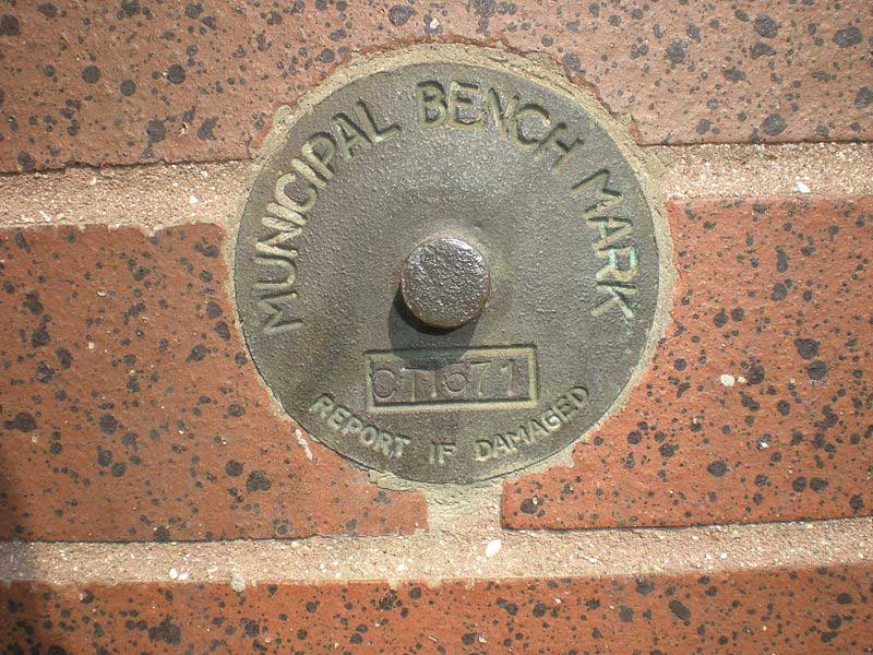
Benchmark (BM): A benchmark is a fixed point of known elevation and the elevation of this point will be noted on it with respect to a datum. The reduced level of the benchmark is used to determine the reduced levels of other points. The benchmark is usually taken as the plinth of an important building, top of parapets of bridges, etc. It will be marked by an identifying mark like a cross mark or a circle with a dot at its centre.
These may be classified in Leveling and Surveying as:
1. G.T.S (great trigonometrical survey) benchmark,
2. Permanent benchmark,
3. Arbitrary benchmark,
4. and Temporary benchmark.
The G.T.S benchmarks are those established by the Survey Departments of a country. These have been established at intervals all over the country with very high precision with reference to the main sea level as the datum.
Their elevations and reduced levels are shown on GTS maps.
The benchmark in the below picture is known as “Permanent benchmarks.” These are marked on well-defined and permanent points such as milestones, corners of plinths of buildings, top of parapets of bridges, etc.
In small surveying and leveling works, the reduced level of a well defined reference point is arbitrarily assumed. These are called “arbitrary benchmarks.”
Temporary benchmarks are the reference points Which are established when there is a break in the work.
Axis of Telescope.
The axis of a telescope is the line joining the optical center of the object glass to the center of the eye piece.
For the above content you can find a video by clicking this link : https://youtu.be/pzX63BgP9PQ


Comments
Post a Comment